Central Oregon Outback 2000 Fly-In
(link to map care of Doug Miller) August 5th through 13th 2000 (link to more photos)

| PPC and PPG flyers and families are invited to attend a 9 day fly-in/camp-out in one of the most scenic areas of the continent, the Outback of Central Oregon. Come fly through canyons, into craters, over interesting rock formations, weave through sand dunes, and enjoy the beauty of the high desert. Scenic flying and camaraderie are the main goals of this loosely structured get together. |
| The flying will center around the city of Bend
(within a 100 mile radius), on Hwy. 97 just east of the Cascade Mountains.
Average ground elevation 3500 ASL. Day time temps average 80 to 90, night
temps 30 to 45, very low humidity, afternoon thunderstorms possible but
not likely. Almost all flying will take place during the first three hours
of day light since thermals and afternoon wind often persist until after
dark, although everyone is free to fly any time they like. Most of the
time we will be taking off and landing on paved runways.
Camping is mostly primitive and undeveloped, and could even be in the parking lot of a rural airport or farm field. Campers, trailers, tents, are fine. Motel accommodations are available near most flying sights, as are grocery stores and gas stations. During the afternoons when flying is not good or if the weather doesn't cooperate, you'll find many things to see and do if you enjoy the outdoors. Those attending should not expect a lot of organization. You'll be on your own, with suggestions and help from us who know the area. Cross country flights are possible if we have people willing to drive chase vehicles. Everyone will be expected to be a courteous flyer so we'll be able to do this for many years to come. Above all BE SAFE. |
| During the fly-in week we will have an opportunity
to visit these areas, and nearby sights:
Prineville: Crooked River Canyon, Smith Rock, Prineville Reservoir, Steens Pillar, possible cross country flight to Madras or Bend. Madras: Lake Billy Chinook, Deschutes River Canyon, great views of the Cascade Mountains, possible cross county flight to Prineville. Bend: Pine Mountain, wide open desert, Mt Bachelor, lava caves, lava flows, high desert museum, Newberry National Monument, Benham Falls. Possible cross country flight to Christmas Valley. Sisters: small airport, great camping, amazing views of the mountains, possible cross country flight to Bend, Madras or Prineville.. Fort Rock: Hole in the Ground Crater, Fort Rock State Park, wide open desert flying. Christmas Valley: Crack in the Ground, Sand Dunes, Dry Lake, rabbits, coyotes, wide open desert flying. |
| Update agenda.
Here is the info on when and where we plan to camp and fly. During the
day there will be plenty to do depending on the individul's likes, spelunking,
bike riding, swimming, fishing, rock climbing, canoeing, museums, shoping,
whatever you like as far as outdoor activities. I havea couple of canoes
available for use. Talk to me for ideas. Plan on cool flying conditions
with warm to hot days. Flying from dry lakes will get dust on everything,
one field is partly gravel, some are pavement.
8-5 Saturday, meet up at Cold Springs campground near Sisters
to camp.Fly Sunday morning from Sisters Airport. To get to Cold Springs
USFS campground
8-6 Sunday, after flying drive to Lake Billy Chinook State Airport to
camp. Fly from there Monday morning. This is a gravel/dry grass strip so
a rock guard is a good idea. Swiming/boating/fishing are available at the
lake about 5 miles from the airstrip. A small convinience store is within
walking distance of the airstrip.
8-7 Monday, after flying take a dip in the lake then drive to Prineville airport or Bill Lee's ranch to camp and fly Tues. morning. I haven't been able to contact Bill so it looks like it will be Prineville. Campers can park overnight at the west end of the airport. Prineville Airport N44 16.822 W120 54.148 Note: I've been in contact will Bill Lee and we'll be going to his ranch for camping and flying instead of Prineville. Directions are from Bend take Hwy 20 east toward Burns about 8 miles. His ranch is on the right just before Dodds Road. Click here for a photo. or see a map for the GPS coordinates. 8-8 Tues., after flying, drive out to Fort Rock (the dry lake bed) to
camp, perhaps stopping at the High Desert Museum, Lava River Cave, or Newberry
Crater
8-9 Wed, after flying, drive over to Christmas Valley dry lake or airport to camp. Spend the afternoon at Crack in the Ground (where it is cooler). Fly the dunes and hunt for wild horses in the morning. N43 18.775 W120 37.824 or airport N43 14.074 W120 40.596 8-10 Thursday, after flying either spend another day at Christmas Valley
or close by Fort Rock, or drive to Chiloquin, Burns, Silver Lake, Paisley,
to camp
8-11 and 8-12 Friday and Saturday, leave these days open to go back
to places we really liked, or places where it was too windy to fly.
|
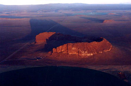
Fort Rock at dawn. |

Chris East at Fort Rock |

Hole in the Ground. Hole in the ground is a mile wide, 600' deep, crater formed by a steam explosion. On this clear day, a cold fog forms in the bottom of the crater resembling a bowl of steaming soup. The tiny spot just above the fog is Chris. TopoZone Link |
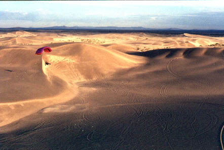
Sand Dunes at Christmas Valley. Desert sand dunes in the middle of nowhere are a great playground for Chris and her PPC. This is a really fun place to fly! Topo Zone Link |
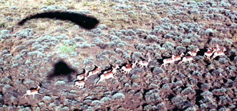
Pronghorn antelope. The fastest land animal in North America. Catching them with a PPC is an exercise in futility. |

Early morning take-off from Prineville Airport |

Approaching the Crooked River Canyon |
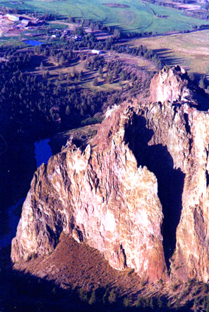
Flying over Smith Rock State Park |
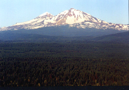
South and Middle Sisters Mountains from near Bend. |
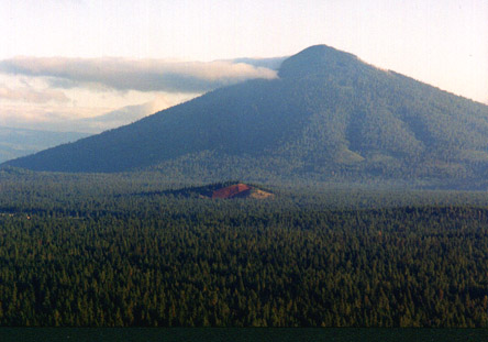
Black Butte from near Sisters |